Skip navigation

The NaturePlus Forums will be offline from mid August 2018. The content has been saved and it will always be possible to see and refer to archived posts, but not to post new items. This decision has been made in light of technical problems with the forum, which cannot be fixed or upgraded.

We'd like to take this opportunity to thank everyone who has contributed to the very great success of the forums and to the community spirit there. We plan to create new community features and services in the future so please watch this space for developments in this area. In the meantime if you have any questions then please email:

Fossil enquiries: esid@nhm.ac.uk
Life Sciences & Mineralogy enquiries: bug@nhm.ac.uk
Commercial enquiries: ias1@nhm.ac.uk

Antarctic conservation

4 Posts tagged with the sea_ice tag
1

Under Pressure

Posted by Conservators Sep 20, 2013

Author: Nicola

Date: 18 September 2013

Temperature: -21C

Wind Speed: 15 knots

Sunrise: 7.10

Sunset: 18.30


photo 1 (Custom).jpg

Heading for a walk amoung the pressure ridges © Josiah


The pond in the village where I grew up would occasionally freeze over in winter and, with my head filled with images of polar explorers, I always wanted to walk onto its thin, enticing shell of ice.  So, this evening it was a great thrill to be able to step from the land in front of Scott Base and onto the 2m thick sea ice.

photo 2 (Custom).jpg

The moon rising above the jagged silhouttes of the broken ice © Nicola


I was heading out to explore the extraordinarily beautiful features known as the pressure ridges.  Formed as the ice is squashed up against the land during winter these jagged walls of ice are slowly forced up into strange, distorted, awe-inspiring shapes. As the tide rises puddles of sea water appear around their base then freeze into ponds of blue ice. The shapes are never static, and over the coming months they will gradually change; fracturing, splitting and sagging under their own weight.

photo 3 (Custom).jpg

A jumble of fractured sea ice and frozen ponds with Mount Erebus behind © Nicola


I carefully followed the safe flagged route, probing the snow in front of me with a pole, checking for new cracks in the ice. In the gloom as the sun went down I was confronted with two massive dark shapes – seals. During the summer hundreds will make their way through the cracks around the pressure ridges and come up for air. I left them peacefully relaxing on the ice and headed back to the base.

photo 4 (Custom).jpg

Seals lying on the ice amoung the pressure ridge walk © Nicola

0

Cape Evans in Context

Posted by Conservators Oct 20, 2011

Author: John

Date: 19 October 2011
Temperature: -27°C
Wind Speed: 0 knots
Temp with wind chill: -27°C
Sunrise: 3.42am
Sunset 11.47pm


In 1910, Captain Robert Falcon Scott led the British Antarctic Terra Nova Expedition. One of the aims was to reach the Geographical South Pole. A hut at Cape Evans on the western side of Ross Island was the base for this expedition. In September 2011, as part of the Antarctic Heritage Trust’s responsibilities, Scott’s Terra Nova Hut was visited for the first time after yet another Antarctic winter, to provide a report on the building’s condition and snow buildup.

Terra Nova.jpg

Terra Nova Hut from the Sea Ice, 17 September 2011. © AHT/John


While overcast, this image is from the sea ice looking east to the southern flanks of Mt Erebus. Wind Vane Hill is just appearing to the right.


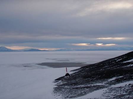
The second image is from the southern flanks of Mt Erebus, at a locality called ‘Room with a View’, looking west over the start of the Erebus Glacier.

Terra Nova Hut from the sea ice.jpg

View West from the Southern Flanks of Mt Erebus, 16 October 2011. © AHT/John


On a beautifully clear and sunny day, this image looks over McMurdo Sound to the Antarctic Continent. Inaccessible Island is to the left, with Little Razorback Island in front. Behind the dark bluff of Turk’s Head to the right is the thin strip of Cape Evans, with a grounded iceberg just off the Cape.
The two images complement each other well and accurately depict the loneliness and isolation of Scott’s Terra Nova expedition hut, particularly in 1910 with no communication back home, and the beauty and vastness of the Antarctic continent.

0

Sun, and Base Duties

Posted by Conservators Aug 30, 2011

Author: John

Date: 27 August 2011

Temperature: -11.2oC

Wind Speed: 22kts

Temp with wind chill: -19.7oC

Sunrise: 10.18am

Sunset: 3.35pm


The sun is getting closer to being visible at Scott Base.  It is actually above the horizon but still behind the hills and peaks of Ross Island.  There are some beautiful light effects and delicate colours to be seen in the sky.  Today there was a narrow, horizontal band of the palest pink in the South, across White and Black Islands, as the sun shone under the clouds in the North.


The sun getting closer! resized.jpg

The Sun Getting Closer!  John/AHT


While keeping a good look out for these beautiful effects, work and life at Scott Base must still go on.  Every Saturday at an All Staff Base Meeting, duties necessary for the smooth running of the Base are apportioned to all staff.


Base duties resized.jpg

Base Duties.  John/AHT


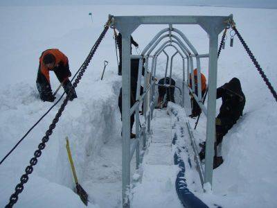
One such duty is the removal of snow and sea ice build up around Reverse Osmosis (RO) Intake/Outlet gantry at the ice transition.  Our team spent nearly two hours shovelling snow, cutting the sea ice with a chainsaw and removing these heavy blocks of ice.


The RO plant supplies all fresh water for the running of the base and provides two degrees of purity, RO1 for general use and a more pure RO2 for drinking, scientific projects, and work such as conservation of the Ross Island historic artefacts.

0

Mindy                      August 4, 2010


Temperature:           -17.0°C
Wind Speed:           10 knots
Temp with wind chill: Approximately -30°C
Moonrise:                Below horizon
Moonset:                 Below horizon


When we arrived at Scott Base (New Zealand’s Antarctic research station) in February, pools of open water were everywhere.  It was hard not to notice the waters of McMurdo Sound through breaks in the ice.


Open waters of McMurdo Sound resized.jpg

The open waters of McMurdo Sound, as viewed from Observation Hill in March. When the sea ice freezes over,

the Cape Armitage Loop runs directly through this area.  © AHT / M. Bell


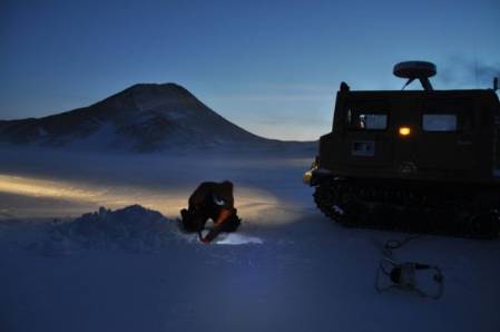
After months of winter, these pools have frozen over.  It is now possible to assess the potential for local travel over the sea ice.  Armed with flags, a GPS unit, measuring tapes, shovels, hot chocolate and a very large drill, we ventured out on to the sea ice.  With Tom, Scott Base winter manager, at the helm, we followed the Cape Armitage GPS route at a cautious pace.  Observing the landscape closely, we stopped to measure, assess and mark potential dangers like cracks in the sea ice.  We also stopped to determine the ice’s thickness at specific points along the route.

Digging into the snow resized.jpg

Digging down through the snow to find the ice surface, with Observation Hill in the background.

© Antarctica New Zealand / T Arnold

Drilling into the ice resized.jpg

Drilling into the sea ice to determine its thickness

© Antarctica New Zealand / T Arnold

As a general rule, a minimum of 75 cm of ice is required for sea ice travel.  Measurements gathered from our trip suggest the portion of the route we surveyed is good to go.  When the route is completely profiled, the path of safe travel will be marked with flags and the fun can begin.  Me, I’m keen to get out for a good ski!